


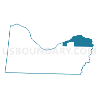
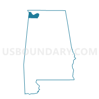
Hatton, Colbert County, Alabama
About
Outline

Summary
| Unique Area Identifier | 521485 |
| Name | Hatton |
| County | Colbert County |
| State | Alabama |
| Area (square miles) | 44.41 |
| Land Area (square miles) | 34.57 |
| Water Area (square miles) | 9.84 |
| % of Land Area | 77.84 |
| % of Water Area | 22.16 |
| Latitude of the Internal Point | 34.80171070 |
| Longtitude of the Internal Point | -87.51371770 |
Maps

Graphs
Select a template below for downloading or customizing gragh for Hatton, Colbert County, Alabama


Neighbors
Neighoring Voting District (by Name) Neighboring Voting District on the Map
- Center Star First Baptist Church, Lauderdale County, AL
- Killen First Baptist Church, Lauderdale County, AL
- Lauderdale Co Bd of Education, Lauderdale County, AL
- Leighton, Colbert County, AL
- Muscle Shoals, Colbert County, AL
- Red Bank Fire Station, Lawrence County, AL
- Sheffield, Colbert County, AL
- Spring Valley Fire Dept., Colbert County, AL
- Town Creek Depot, Lawrence County, AL
Top 10 Neighboring County Subdivision (by Population) Neighboring County Subdivision on the Map
- Florence CCD, Lauderdale County, AL (50,499)
- Tri-Cities CCD, Colbert County, AL (33,934)
- Killen CCD, Lauderdale County, AL (16,161)
- Leighton CCD, Colbert County, AL (8,253)
- Town Creek-Courtland CCD, Lawrence County, AL (4,655)
Top 10 Neighboring Place (by Population) Neighboring Place on the Map
Top 10 Neighboring Unified School District (by Population) Neighboring Unified School District on the Map
- Lauderdale County School District, AL (53,390)
- Lawrence County School District, AL (34,339)
- Colbert County School District, AL (23,875)
- Muscle Shoals City School District, AL (13,091)
- Sheffield City School District, AL (9,039)
Top 10 Neighboring State Legislative District Lower Chamber (by Population) Neighboring State Legislative District Lower Chamber on the Map
- State House District 1, AL (47,247)
- State House District 2, AL (45,462)
- State House District 3, AL (42,348)
- State House District 7, AL (40,956)
Top 10 Neighboring State Legislative District Upper Chamber (by Population) Neighboring State Legislative District Upper Chamber on the Map
Top 10 Neighboring 111th Congressional District (by Population) Neighboring 111th Congressional District on the Map
Top 10 Neighboring Census Tract (by Population) Neighboring Census Tract on the Map
- Census Tract 116.04, Lauderdale County, AL (6,610)
- Census Tract 115.01, Lauderdale County, AL (6,260)
- Census Tract 207.01, Colbert County, AL (6,103)
- Census Tract 207.03, Colbert County, AL (5,175)
- Census Tract 9792, Lawrence County, AL (4,655)
- Census Tract 208.01, Colbert County, AL (4,487)
- Census Tract 207.04, Colbert County, AL (4,321)
- Census Tract 108, Lauderdale County, AL (3,797)
- Census Tract 201, Colbert County, AL (3,467)
- Census Tract 101, Lauderdale County, AL (1,959)
Top 10 Neighboring 5-Digit ZIP Code Tabulation Area (by Population) Neighboring 5-Digit ZIP Code Tabulation Area on the Map
- 35630, AL (32,629)
- 35661, AL (16,617)
- 35645, AL (14,060)
- 35634, AL (9,711)
- 35660, AL (9,042)
- 35672, AL (6,445)
- 35646, AL (4,635)